
For complete flexibility a Total Station that is ready for any challenge. Designed for mid accuracy applications. As standard, an alpha-numerical keyboard and a complete set of application software is included. If more convenient, use Bluetooth® wireless technology to connect any data collector, e.g. the Leica CS10/15. For additional flexibility, a wide range of options ensures that you can always count on your TS06 Total Station.
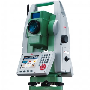
Leica FlexLine TS06plus Total Station
Product Description
Built-in user friendliness by the full alpha-numerical keyboard and the high resolution display
Fast and easy entry of numbers, letters and special characters, e.g. for coding
At-a-glance viewing on the largest high-resolution display in its class
Best-in-class Electronic Distance Measurement (EDM)
With PinPoint EDM, FlexLine plus delivers the optimal balance of range, accuracy, reliability, beam visibility, laser dot size and measurement time.
1.5 mm + 2 ppm to prism
2 mm + 2 ppm to any surface
Extremely fast (1 second)
1000 m range without a prism
Coaxial laser pointer and measurement beam
Flexible Data Exchange
USB Stick for fast and easy transfer of data (GSI, DXF, ASCII, LandXML, CSV, user-defined)
Built-in wireless Bluetooth for cable-free connection to any data logger, e.g. the field controller Leica Viva CS10 or CS15
Theft protection by Leica Geosystems – mySecurity
mySecurity gives you total peace of mind
If your instrument is ever stolen, a locking mechanism is available to ensure that the device is disabled and can no longer be used
FlexField & FlexOffice Software
FlexField on-board software and optional FlexOffice Software offer a broad range of functionality to cover all tasks. Benefit from simplicity and functionality in one solution.
Application Programs Included:
Topography (Orientation & Surveying), Stake Out, Resection, Height Transfer, Construction, Area (Plan & Surface), Volume Calculation, Tie Distance (MLM), Remote Height, Hidden Point, Offset, Reference Line, Reference Arc, Reference Plane, COGO, Road 2D.